グーグルアースプロの限界 usability of Google Earth Pro

パスpathの精度
drone測量で,公共座標点がうまく取得出来ていない場合,drone測量結果を編集する際,グーグルアースプロを使う誘惑に駆られてしまった。2地点間の距離は,垂直成分を含むのかどうか,という点が最も気になったことであった。Google Earth Help > Community に情報があった。
Does the Google Earth path tool consider the elevation during the distance measurement?
ここでは,水平距離200mほどの丘の測量値とGoogle Earth Proのパス測定値との大きなズレなどについて,質問している。質問のタイトルだけではない。
さて,GEProの技術者の回答は次のようだ。
Alchemist251
Diamond Product Expert
May 13, 2021
HI Arun,
For some reason, your post just showed up in the Google Earth forum today, May 12.
The digital elevation model used for most of the earth is from the SRTM recorded in February 2020. It’s a general survey and not specifically accurate by any standard. It simply happens to be the only digital elevation data that covers most of the earth. In the US, elevation data points are 30 meters apart and everything in between is interpolated. In other areas, the points may be 90 meters apart. The Jet Propulsion Lab will only guarantee accuracy of the data points as +/- 16 meters 95 % of the time.
There’s no documentation of how the elevation profile works. Over the years, it has had various glaring errors. You can’t use it for the level of accuracy you’re looking for.
I know that doesn’t help but it’s the situation that exists.
上記中の精度の記述で注目されるのは,赤字の部分だ。only guarantee accuracy of the data points as +/- 16 meters 95 % of the time これには驚いたし,なるほどと納得された。
さらに,他の技術者が回答している。
Alchemist251
Diamond Product Expert
May 14, 2021
Arun, the ruler path tool doesn’t consider elevation change. This is in line with how surveyors measure property. So, if a piece of property contains a cliff, you get the face of the cliff for free. That doesn’t help hikers much, I know.
距離に垂直成分は含まないということである。光波測距儀を使った結果との比較をしてみようと思っていたが,まあ,技術的な意味はゼロであることがわかった。まあ,ゼロでも,ここに後に提示したいと思っている。
以上,Dec. 1, 2023記。
GEProで使用されている画像の使い方を考える
Help Center > Community: Explore the EarthHow images are collected は参考になった。衛星写真や空中写真はモザイク利用がなされており,シームレスに繋げられている,ということだ。このシームレスに繋ぐ技術って,当方は凄いなあ,と思っている。3Dオブジェクトは空中の撮影場所が変われば大きく倒れ込む。これをできるだけ防ぐ技術があるのだ。ちょっと気になって,スカイツリーを見たくなった。
以上,13:08,Dec. 1, 2023記。
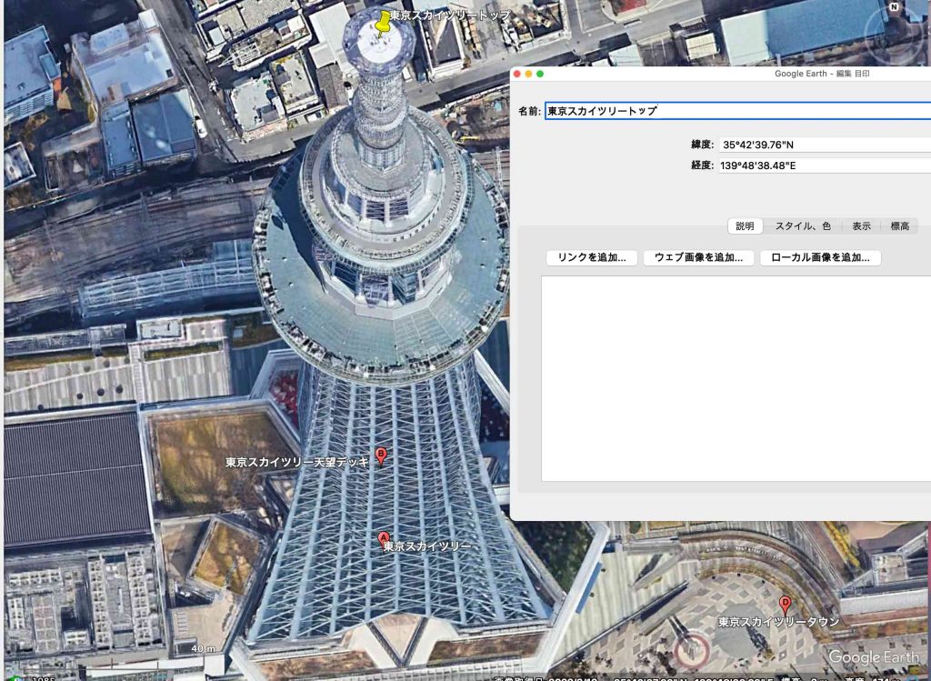
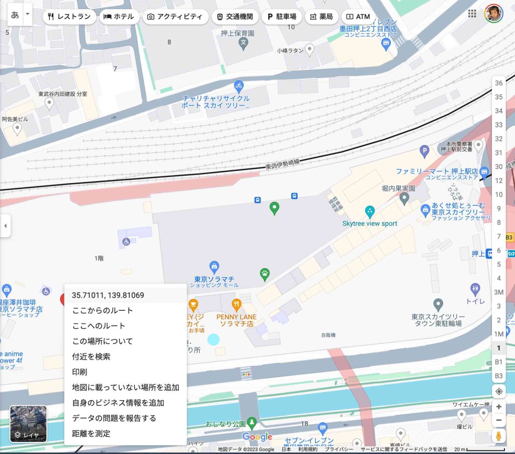
予想していたけれども,GEProでのスカイツリーは,360度回転しても,この図1の写真が回転するだけだ。関東地方全域が入るように縮小表示しても画像のどの部分も変わらない。当然ながらオルソ画像ではなくて,モザイク写真だ。GEPro内からGoogle Map表示にすると,写真モードで同じ画像が表示されるが,地図モードにして表示したのが,図2である。スカイツリーの構造体は表示されず,東京スカイツリーという表示があるだけだ。この緯度と経度を見ると,35.71011, 139.81069とある。図1でタワートップの白い円盤の中央にプッシュピンをセットして,その経緯度を見ると,35º42′39.76″N, 139º48′38.48″Eとある。
図2のDEG(度10進)値35.71011, 139.81069をDMS形式に換算すると,それぞれ,35º42′39.396″N, 139º48′38.484″Eとなり,緯度に多少の違いがある。何れが正しいのか,不明ではあるが,恐らく図2に係わるDEG(度10進)値が正しいのだろうと思う。図1の写真を使ってタワートップ中央にプッシュピンを配置する方法は,精度を求めるならば,不適当と言える。
GEProの位置精度
さて,こうなると,Google Earth Proの測量利用への期待値は大きく下がって,使えるかも知れないのは,唯一,位置情報ということになる。図1から想定できるが,見える画像とプッシュピンで刺した地球上の位置は,厳密には合致しない。水平位置というタームは,厳密には不適当で,今後は空間解像度 spatial resolutionという表現にしたい。GEは,米軍の使用で始まるWGS84 ellipsoid parameters and UTM projection,が使用されている。
このテーマでの報告はかなりの数に上るだろう。そのうち,4件を簡潔にここで引用する。
3の文献はナイジェリアでのGoogle Earth(GE)とSRTM(the Shuttle Radar Topography Mission v3.0)の画像の2000〜2018年の比較をしたものである。この期間を4期に分けており,RMSEs (the root mean square errors)の評価をしている。水平精度hotizontal accuracyに注目すると,
In terms of the horizontal accuracy, the root mean square errors (RMSEs) are as follows – year 2000 (29.369m), year 2008
(28.391m), year 2012 (10.615m) and year 2018 (10.603m). The most recent GE imagery (year 2018) was the most accurate while year 2000 was the least accurate. This shows a continuous enhancement in the accuracy and reliability of satellite imagery data sources which form the source of Google Earth data.
とあり,GEの精度は年々,改善されていることがわかる。
そのため,古い文献をみても現状を知ることはできないのである。1の文献では地域別の評価がなされており,Southeast and East Asiaが最も精度が低くなっていることはわかるのである。日本がGEにとってどう評価されているのかは不明で,Europe並の精度が提供されているかは不明である。2の文献はナイジェリアでの評価であるが,奇妙に高い精度を示していて,他の評価との間に大きな懸隔がある。
結局,使用可能なのは,4の文献である。著者5人全員が,北京の研究所のスタッフで中国人であるが,オーストラリア大陸での評価をしている。要旨を次に示す。発行年次は2021年であるが内容は3の文献よりも2年ほど新しく,最新の内容を持った文献と言える。
ABSTRACT: Since the release of Google Earth image data, it has been the most widely used remote sensing data worldwide, and its accuracy evaluation has also been the focus of historical research. However, the researchers found that Google Earth’s image accuracy assessment results have obvious regional characteristics. This article uses the Australian continent as the research area and WorldView-2 remote sensing images as reference data to study the accuracy evaluation results of Google Earth data. The research shows that the overall accuracy of the assessment area in Australia is better. The areas with the best overall accuracy appear in the western coastal areas, with an accuracy range of 0.7-1.4; the accuracy assessment results in the central desert area are also better, with the accuracy range 1.4-2.2, and the areas with the worst accuracy appear in the western mountains and hills of 14.5 and17.1.
現在公開されているものとしては最も高い精度のWorld View – 2 (WV)と比較しており,結局,地形環境の違いが精度を決めているということになる(図1の23カ所のレーベルが欠落しており,論文の議論が理解しがたい点が多々有るが,リモートセンシングを使いこなしていない当方としては知識そのものには,興味は感じた次第)。起伏や植生が多い山岳地域よりも,砂漠や海岸での精度が高くなっている。日本の離島の海岸での精度をこれから推し量ることは無謀かも知れないが,空間解像度は,1〜2mほどの精度ではないかと考えられるのである。
この4の文献は,他の3点の文献の流れと対照して,違和感はなく,信頼して良いものと思う。この1〜2mという情報は,グーグルアースを自らの測量の補助として使い得ると感じて,安堵したところである。画像そのものではなく,pushpinを刺した地点の地球上の位置精度の意味と考えてのことである。
以上,Dec. 2, 2023記。